Wednesday, 30 April 2008
Tuesday, 29 April 2008
Monday, 28 April 2008
Sunday, 27 April 2008
Yr13 Managing Cities: Renewal of Magdalen Strret
Links to documents about renewing the Magdalen Street and St Augustine area of Norwich
Council Plans
What happened in the 1960's
HERS funding (Heritage Economic Regeneration Scheme)
Related news stories
Area action plan
Council Plans
What happened in the 1960's
HERS funding (Heritage Economic Regeneration Scheme)
Related news stories
Area action plan
Friday, 25 April 2008
Unreported World
Keep an eye on Unreported World on Channel 4 on Friday night (7.35). There have been programmes on climate change and flooding in Bangladesh and how the price of gold in the rainforest is affecting the people who live there. Next week is on rubbish collection in Egypt. Clickhere for more details or watch below
Egypt Part 1
Egypt Part 2
Egypt Part 3
Bangladesh Part 1
Bangladesh Part 2
Bangladesh Part 3
Egypt Part 1
Egypt Part 2
Egypt Part 3
Bangladesh Part 1
Bangladesh Part 2
Bangladesh Part 3
Thursday, 24 April 2008
Wednesday, 23 April 2008
Tuesday, 22 April 2008
Monday, 21 April 2008
Year 12: Migration
Miss Holmes Year 12 Geography class.
Click on the link and watch this clip on why a Polish man (Adam) migrated to the UK. Most of you missed a personal view in this section of your project so add some of these ideas after listening to him. :)
http://www.youtube.com/watch?v=Wfz7EeykRLQ
Click on the link and watch this clip on why a Polish man (Adam) migrated to the UK. Most of you missed a personal view in this section of your project so add some of these ideas after listening to him. :)
http://www.youtube.com/watch?v=Wfz7EeykRLQ
Sunday, 20 April 2008
Yr12 Climatic Hazards or Yr 13 Managing Cities
Hurricane Katrina and the how they are trying to look after the population
http://news.bbc.co.uk/1/hi/world/7349848.stm
http://news.bbc.co.uk/1/hi/world/7349848.stm
Friday, 18 April 2008
Yr12 and 13: Climate Change
WASHINGTON - Planet Earth continues to run a fever. Last month was the warmest March on record over land surfaces of the world and the second warmest overall worldwide. For the United States, however, it was just an average March, the National Oceanic and Atmospheric Administration reported Thursday.
NOAA's National Climatic Data Center said high temperatures over much of Asia pulled the worldwide land temperature up to an average of 40.8 degrees Fahrenheit (4.9 degrees Celsius), 3.2 degrees (1.8 C) warmer than the average in the 20th century. While Asia had its greatest January snow cover this year, warm March readings caused a rapid melt and March snow cover on the continent was a record low. Global ocean temperatures were the 13th warmest on record, with a weakening of the La Nina conditions that cool the tropical Pacific Ocean. Overall land and sea surface temperatures for the world were second highest in 129 years of record keeping, trailing only 2002, the agency said. Warming conditions in recent decades have continued to raise concern about global climate change, which many weather and climate experts believe is related to gases released into the atmosphere by industrial and transportation processes
Thursday, 17 April 2008
Yr13 Hazards: Why MEDC's have a lower death toll
Trained volunteer emergency workers from Elk Grove, Galt and Sacramento are scheduled to leave Saturday for an earthquake response drill in Clovis. The Community Emergency Response Team members are from the Cosumnes, Sacramento Metropolitan and Sacramento fire departments. The CERT program provides basic training in disaster survival and rescue skills so adult volunteers can provide vital services during a disaster.
The team members are scheduled to leave from the Cosumnes' fire training facility in Elk Grove Saturday. The Clovis CERT team, which is new, had asked Sacramento-area teams to help conduct training classes during the the weekend drill. Sacramento-area team members are scheduled to return to Elk Grove Sunday.
Wednesday, 16 April 2008
Yr13 Managing Cities: London Low Emission Zone
For details on charging people to drive into London view the video clips below.
http://www.bbc.co.uk/mediaselector/check/player/nol/newsid_7290000/newsid_7293000?redirect=7293083.stm&news=1&bbwm=1&nbwm=1&nbram=1&bbram=1
< http://www.bbc.co.uk/mediaselector/check/player/nol/newsid_7170000/newsid_7171900?redirect=7171917.stm&news=1&nbram=1&bbwm=1&nbwm=1&bbram=1 >
Can you evaluate its success?
Yr 12 and Yr13 Norwich next the Sea?
This is substantially more than the Intergovernmental Panel on Climate Change (IPCC) forecast in last year's landmark assessment of climate science.
Sea level rise of this magnitude would have major impacts on low-lying countries such as Bangladesh.
The findings were presented at a major science conference in Vienna.
The research group is not the first to suggest that the IPCC's forecast of an average rise in global sea levels of 28-43cm by 2100 is too conservative.
The IPCC was unable to include the contribution from "accelerated" melting of polar ice sheets as water temperatures warm because the processes involved were not yet understood.
Melt water
The new analysis comes from a UK/Finnish team which has built a computer model linking temperatures to sea levels for the last two millenia
"For the past 2,000 years, the [global average] sea level was very stable, it only varied by about 20cm," said Svetlana Jevrejeva from the Proudman Oceanographic Laboratory (POL), near Liverpool, UK.
"But by the end of the century, we predict it will rise by between 0.8m and 1.5m.
"The rapid rise in the coming years is associated with the rapid melting of ice sheets."
The model, she told reporters here at the European Geosciences Union (EGU) annual meeting, is able to mimic accurately sea levels reliably observed by tide gauges over the last 300 years.
There is little concrete evidence on sea levels for the thousands of years before that, explained POL's Simon Holgate, who was not involved in the new study.
"There is some limited archaeological evidence [based on] the sill heights of fish enclosures that the Romans used, that's probably the strongest evidence that there hasn't been any significant change in sea level over the last 2,000 years."
Against that, he said, the currently observed rise of about three mm per year is significant, and many scientists working in the field expect to see an acceleration.
Last year, German researcher Stefan Rahmstorf used different methodology but reached a similar conclusion to Dr Jevrejeva's group, projecting a sea level rise of between 0.5m and 1.4m by 2100.
Space-eye view
The latest satellite data indicates that the Greenland and West Antarctic ice sheets are losing mass, though the much bigger East Antarctic sheet may be gaining mass.
A full melting of Greenland and West Antarctica would raise sea levels by many metres; but the process, if it happened, would take centuries.
"We know what's happening today from satellite data, but trying to predict what that means in the future is very difficult science," noted Steve Nerem from the University of Colorado, whose own research concerns global sea levels.
"There's a lot of evidence out there that we're going to see at least a metre of sea level rise by 2100," he said.
"We're seeing big changes in Greenland, we're seeing big changes in West Antarctica, so we're expecting this to show up in the sea level data as an increase in the rate we've been observing."
However, a rise of even a metre could have major implications for low-lying countries - especially, noted Dr Holgate, those whose economies are not geared up to build sophisticated sea defence systems.
"Eighty to 90% of Bangladesh is within a metre or so of sea level," he said, "so if you live in the Ganges delta you're in a lot of trouble; and that's an awful lot of people."
Tuesday, 15 April 2008
Yr12 Rainforests - using technology to help fight illegal logging
Amazon tribe turns to cyberspace for survival
Chief Almir Surui from the Surui-Paiter indigenous people of Brazil, attends the launch of the new Google Earth Outreach programme in London. You may know it as Google, but in bamboo-and-thatch roundhouses deep in the Amazon rainforest the iconic brand goes by another name. The Surui people, one of the most remote on Earth, call it ragogmakan - messenger - and they're banking on the search engine to save them and their ancestral lands from extinction.
Chief Almir Surui from the Surui-Paiter indigenous people of Brazil, attends the launch of the new Google Earth Outreach programme in London. You may know it as Google, but in bamboo-and-thatch roundhouses deep in the Amazon rainforest the iconic brand goes by another name. The Surui people, one of the most remote on Earth, call it ragogmakan - messenger - and they're banking on the search engine to save them and their ancestral lands from extinction.
The tribe - whose first contact with the modern world was less than 40 years ago - is replacing its bows and arrows with hi-tech gadgets in its battle for survival. They have begun using satnav on their traditional trails through the trees. And Google Earth has agreed to provide high-resolution satellite images of their forest home. The initiative is the brainchild of their chief, Almir Narayamoga Surui, who is leading their struggle against illegal loggers besieging their territory, an isolated 242,811ha green oasis in Rondonia, in the wild Brazilian west.
Last year the 34-year-old Almir visited Google near San Francisco to ask it to help monitor the loggers' incursions. He said he also hoped to be able to use the internet firm to "alert the world". He added: "We call Google ragogmakan because we hope it will help us get our message out."
For countless centuries the nomadic people - who call themselves Paiter, meaning simply "we ourselves" - lived far from the outside world, until the official "first contact" with Brazilian authorities on September 7, 1969, national Independence Day "The date that Brazil became independent was the day our independence ended," Almir says. "Our people were very, very scared when they first saw white men." A warrior people (Surui, the name bestowed on them by outsiders, means enemy), they decided to fight. "We thought we could beat them with bows and arrows," says Almir. "But it didn't work."
The Surui were reduced from 5000 to just 250 people by massacres and diseases such as chicken pox, measles, tuberculosis and flu, to which they had no immunity. They got medical help, but lost half their land, and only got the remainder protected after a prominent Surui drew an arrow on a leading Brazilian senator in his office and demanded official demarcation. The land is still under constant attack. Almir says that 300 sawmills, employing 4000 people, surround it and other Indian reserves in the area. Eleven chiefs have been killed trying to protect their land, and he himself has a 170,000 reais ($127,000) price on his head. And Almir envisages the Surui with solar-powered laptops using Google to download information and to tell the world how their forest is much more valuable if left standing.
Yr 13 Mass Movement: How important is the role of water in different types of mass movement?
Homes teeter on seaside land slip
One family has been told to move out of their home by insurers Thousands of tonnes of earth have slipped away in front of homes on the Yorkshire coast leaving properties precariously balanced on a cliff edge. Gardens and patios at Knipe Point are now in a heap 100ft (30.4m) below the homes on National Trust land at Cayton Bay, between Scarborough and Filey. Insurers have told one family to move out, while other locals wait for news. A trust spokesman said the slip had been caused by water and it was impossible to predict the next one.
Michael Turner of the Residents' Association said there was growing concern in the area. "People are very worried because at the moment they don't know what's going to happen, whether there will be any more slippage. "One family has been told to move out by their insurance company. "We're just waiting for the results of investigations into what caused the land slip, but at the moment we're in limbo."
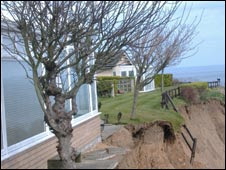
National Trust property manager Bob Dicker said: "We know that this land is slipping, we know it's very active at the present time, but to put a scale on it at this stage would be unwise. We don't have enough information. "What we're finding out, in some respects it's very obvious, we're finding out it is a land slip and we should be very careful to remember that - it isn't coastal erosion. "The land slip itself is caused by water for the most part, there may be other causative agents, but mainly water. "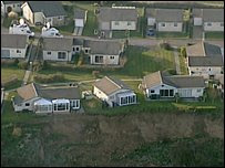
Mr Dicker said engineers were trying to find the source of the water that caused the slip. "What we don't know is where is the water coming from and what sources there are in the immediate area. " He said the land slippage had been happening in "fits and starts" and there had been quite a bit of activity for the last two or three months. "Prior to that it had been very stable, if I can use that word, for quite some time. "But it would be very foolish of me or anybody else to predict at the present time just what will happen either today or in ten years time. "We do hope to have more information fairly soon."
One family has been told to move out of their home by insurers Thousands of tonnes of earth have slipped away in front of homes on the Yorkshire coast leaving properties precariously balanced on a cliff edge. Gardens and patios at Knipe Point are now in a heap 100ft (30.4m) below the homes on National Trust land at Cayton Bay, between Scarborough and Filey. Insurers have told one family to move out, while other locals wait for news. A trust spokesman said the slip had been caused by water and it was impossible to predict the next one.
Michael Turner of the Residents' Association said there was growing concern in the area. "People are very worried because at the moment they don't know what's going to happen, whether there will be any more slippage. "One family has been told to move out by their insurance company. "We're just waiting for the results of investigations into what caused the land slip, but at the moment we're in limbo."
National Trust property manager Bob Dicker said: "We know that this land is slipping, we know it's very active at the present time, but to put a scale on it at this stage would be unwise. We don't have enough information. "What we're finding out, in some respects it's very obvious, we're finding out it is a land slip and we should be very careful to remember that - it isn't coastal erosion. "The land slip itself is caused by water for the most part, there may be other causative agents, but mainly water. "
Mr Dicker said engineers were trying to find the source of the water that caused the slip. "What we don't know is where is the water coming from and what sources there are in the immediate area. " He said the land slippage had been happening in "fits and starts" and there had been quite a bit of activity for the last two or three months. "Prior to that it had been very stable, if I can use that word, for quite some time. "But it would be very foolish of me or anybody else to predict at the present time just what will happen either today or in ten years time. "We do hope to have more information fairly soon."
Yr 12 and 13: A Level revision podcasts or geogpods
Try these podcasts for easy to listen to casestudies
1. http://www.stmschool.org.uk/geogpod.html- GCSE level but still very useful
2. http://cgz.e2bn.net/e2bn/leas/c99/schools/cgz/accounts/staff/rchambers/GeoBytes/GCSE%20Revision/Podcasts/Coasts%20Podcast/Podcast_GCSE_revision_hmp.html
Mainly physical geography
there are plenty more on the web - google A Level Geography podcast and see what comes up!!
WHY NOT DO YOUR OWN!!!????
Monday, 14 April 2008
Yr13 Hazards: How predictable are earthquakes?
California faces an almost certain risk of being rocked by a strong earthquake by 2037, scientists said Monday in the first statewide temblor forecast. New calculations reveal there is a 99.7 percent chance a magnitude 6.7 quake or larger will strike in the next 30 years. The odds of such an event are higher in Southern California than Northern California, 97 percent versus 93 percent. "It basically guarantees it's going to happen," said Ned Field, a geophysicist with the U.S. Geological Survey in Pasadena and lead author of the report. The 1994 Northridge earthquake under Los Angeles' San Fernando Valley was magnitude 6.7. It killed 72 people, injured more than 9,000 and caused $25 billion in damage in the metropolitan area. The damage created by an earthquake depends greatly on where it hits. A 7.1 quake — much stronger than Northridge — hit the Mojave Desert in 1999 but caused only a few injuries and no deaths. California is one of the world's most seismically active regions. More than 300 faults crisscross the state, which sits atop two of Earth's major tectonic plates, the Pacific and North American plates. About 10,000 quakes each year rattle Southern California alone, although most of them are too small to be felt.
The analysis is the first comprehensive effort by the USGS, Southern California Earthquake Center and California Geological Survey to calculate earthquake probabilities for the entire state using newly available data. Previous quake probabilities focused on specific regions and used various methodologies that made it difficult to compare. For example, a 2003 report found the San Francisco Bay Area faced a 62 percent chance of being struck by a magnitude 6.7 quake by 2032. The new study increased the likelihood slightly to 63 percent by 2037. For the Los Angeles Basin, the probability is higher at 67 percent. There is no past comparison for the Los Angeles area.
Scientists still cannot predict exactly where in the state such a quake will occur or when. But they say the analysis should be a wake-up call for residents to prepare for a natural disaster in earthquake country. Knowing the likelihood of a strong earthquake is the first step in allowing scientists to draw up hazard maps that show the potential severity of ground shaking in an area. The information can also help with updating building codes and emergency plans and setting earthquake insurance rates. "A big earthquake can happen tomorrow or it can happen 10 years from now," said Tom Jordan, director of the earthquake center, which is headquartered at the University of Southern California.
Researchers also calculated the statewide probabilities for larger temblors over the same time period. Among their findings: There is a 94 percent chance of a magnitude 7 shock or larger; a 46 percent chance of a magnitude 7.5 and a 4.5 percent chance of a magnitude 8. The odds are higher that a magnitude 7.5 quake will hit Southern California than Northern California — 37 percent versus 15 percent. Of all the faults in the state, the southern San Andreas, which runs from Parkfield in central California southeast to the Salton Sea, appears most primed to break, scientists found. There is a 59 percent chance in the next three decades that a Northridge-size quake will occur on the fault compared to 21 percent for the northern section. The northern San Andreas produced the 1906 San Francisco earthquake, but the southernmost segment has not popped in more than three centuries. Scientists are also concerned about the Hayward and San Jacinto faults, which have a 31 percent chance of producing a Northridge-size temblor in the next 30 years. The Hayward fault runs through densely populated cities in the San Francisco Bay Area. The San Jacinto fault bisects the fast-growing city of San Bernardino east of Los Angeles.
Yr13 - reducing river pollution
A new skimming device on a boat has helped make the river so clean seahorses have been breeding in it! Watch here
Sunday, 13 April 2008
Yr13 Earthquakes: Update from Balakot
Pakistan earthquake 2005. Video update at this limk
http://www.tv3.co.nz/Home/News/Display/tabid/209/articleID/52352/Default.aspx?src
http://www.tv3.co.nz/Home/News/Display/tabid/209/articleID/52352/Default.aspx?src
Yr12 Climatic Hazards: Are Tropical Revolving storms linked to climate change?
Hurricanes are unlikely to become more frequent as the world warms, according to a new analysis by a scientists who until now had supported a link between global warming and tropical cyclone activity. But they may still become more intense.
"The hurricane expert, Kerry Emanuel of the Massachusetts Institute of Technology, unveiled a novel technique for predicting future hurricane activity this week," "The new work suggests that, even in a dramatically warming world, hurricane frequency and intensity may not substantially rise during the next two centuries."
2007 saw fewer hurricanes than expected, though there were several rapidly-intensifying cyclones in the Atlantic basin. The early prediction for 2008 is for an above-average year filled with frequent storms and several intense hurricanes.
The art of hurricane prediction, even just a few weeks ahead of a season, is young. Scientists readily acknowledge that the list of unknown influences on hurricane activity is likely to be long.
"Scientists wrangling with the hurricane-global warming question have faced two primary difficulties. The first is that the hurricane record before 1970 is not entirely reliable, making it nearly impossible to assess with precision whether hurricane activity has increased during the last century. The second problem comes through the use of computer models to predict hurricane activity. Most climate models, which simulate global atmospheric conditions for centuries to come, cannot detect individual tropical systems."
Yr12 Water on the land: Should we let North Norfolk Flood????
Check out these for information and make your own mind up
http://news.bbc.co.uk/1/hi/england/norfolk/3710082.stm
http://new.edp24.co.uk/search/story.aspx?brand=EDPOnline&category=News&itemid=NOED28%20Mar%202008%2008:37:53:153&tBrand=EDPOnline&tCategory=search
http://news.bbc.co.uk/1/hi/england/norfolk/3710082.stm
http://new.edp24.co.uk/search/story.aspx?brand=EDPOnline&category=News&itemid=NOED28%20Mar%202008%2008:37:53:153&tBrand=EDPOnline&tCategory=search
Yr12 Industrial Change: Gran gets own back
If you are being taken for a ride by Tesco then get your own back. See how at this link
Friday, 11 April 2008
Yr13 Hazards: New China network can report earthquakes within 10 minutes
China's earthquake monitoring department managed to detect and report an earthquake within 10 minutes with a new digital network, the China Earthquake Administration (CEA) announced on Friday. The network, under construction since June 2004, passed an examination by a 19-member expert panel here on Friday. Until now, it's taken 30 minutes to report an earthquake, said Chen Xinlian, the CEA's chief engineer for the new network.
The new network can detect a quake as small as 2.5 on the Richter scale, compared with 4.5 now, he said. In six areas of China that have volcanic activity, it can detect an earthquake of just 1.0 on the Richter scale, he added. As part of the 2.28 billion yuan (US$ 330 million) project, China built state-of-the-art detecting stations in all 31 provincial divisions in the mainland and linked them by computer. "The new milestone network will take China's earthquake monitoring capacity to a new stage," said Chen Jianmin, the CEA director.
According to an earlier CEA report, China has about 1,200 earthquake monitoring stations and 25 provincial divisions have set up emergency teams for earthquake rescue and relief. China, sitting between the Indian Ocean and Pacific plates, is one of the areas with the most tectonic activity in the world.
Yr13 Managing Cities Should you pay more for your parking if you have a bigger car?
On 8th May 2008 new parking permit prices come into force in Norwich. You will now have to pay according to the size of your car to park in certain residential streets (see attached website - go to information leaflet)
http://www.norwich.gov.uk/webapps/atoz/service_page.asp?id=1648
Is this 'fair' Are families with kids (who need a larger car) being punished? or should we all drive.....

Norwich is the first in the UK to do this, it is being watched with interest by other councils.......
http://www.norwich.gov.uk/webapps/atoz/service_page.asp?id=1648
Is this 'fair' Are families with kids (who need a larger car) being punished? or should we all drive.....
Norwich is the first in the UK to do this, it is being watched with interest by other councils.......
Yr12 Industrial Change
Should Tesco be allowed to build on Unthank Road? Click the link to watch the video.
Yr13 Hazards: Monserrat
Monserrat is a British overseas territory in the Lesser Antilles in the Carribbean. You can click on the map to zoom in or out.
View Larger Map
The Soufriere (Sulphur) Hills volcano erupted in 1995 and has been erupting to a lesser extent ever since. This was the first eruption since the 17th Century. The capital city of Plymouth was covered in pyroclastic flow and lahars. The capital was exacuated and the tourist industry destroyed. There were riots as local people felt that not enough was being done by the British governement to help. Currently there is a large exclusion area of much of the island to protect people from the continuing eruption. The lava is an andestic with the volcano being located on a destructive plate boundary. The silica from the subducted plate makes the lava viscous, trapping gas and allowed pressure to buid before the eruption. Thus you get powerful but infrequent eruptions.
Recently Mrs Swain returned from a holiday with these photos.


Thursday, 10 April 2008
Yr13 Hazards Doctor Who
Doctor Who on Saturday is based in Pompeii during the eruption. Tune in and play "Spot the Inaccuracy". Mr M
Wednesday, 9 April 2008
Yr13 Managing Cities: How effective is the London Congestion Charge?
This was on the BBC website today. Mr M
Congestion charge hike 'will increase CO2'
Researchers say people will drive further to avoid paying the fee. The planned emissions-linked congestion charge will result in an increase in carbon dioxide (CO2), a study shows. King's College experts predicted a rise in CO2 levels in outer London would outweigh the benefits of CO2 saved by the £25-a-day fee in inner London. Researchers said this would be largely caused by people driving further to avoid the congestion charging zone. London mayor, Ken Livingstone, plans to raise the daily charge from £8 to £25 from 27 October. Under the plans the cars emitting the highest amounts of CO2 will have to pay a £25 congestion charge whereas cars with the lowest emissions will get a 100% discount.
It showed that by 2012 the increase in CO2 in outer London would be almost 184,000 tonnes, with just 2,200 tonnes saved in central London, giving an overall increase of 182,000 tonnes. The report concluded that because of the new charge, drivers were likely to increase their mileage outside of, and around, the zone and thus increase their emissions.
Subscribe to:
Posts (Atom)